
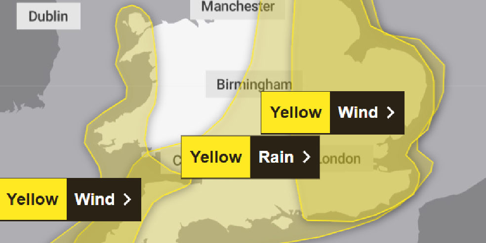
The Met Office has issued two separate weather warnings for Thursday (23 October) with high winds and heavy rain expected.
The rain is expected to arrive first – with the “yellow warning” in force from midnight until 9pm. As much as 2in or 50mm could fall in places.
And the wind is expected to whip up as the morning wears on, with the yellow warning in force from 9am until midnight. Gusts could reach as high as 75mph.
Both warnings cover a wide area – including Brighton and Hove and the whole of Sussex – and they follow localised flooding in the recent heavy rainfall including in Portslade Old Village.
The official forecaster said: “A complex area of low pressure over the mid-Atlantic early this week is expected to move towards the UK while deepening.
“Confidence in the details of its track and intensity as it crosses the UK remains fairly low.
“Despite these uncertainties, there is at least a medium likelihood that an extensive and in places heavy swathe of rain will move into south western Britain during Wednesday evening and spread quickly north east, with totals by early Thursday morning of widely 20mm to 30mm and for some places 30mm to 50mm.
“There is a small chance a few places could exceed this, most likely over North Devon and Cornwall and more generally in the east of the highlighted area.
“In association with the rain, conditions are expected to turn windy with a chance of gales, initially along southern and eastern coasts, but more widely across southern Britain during Thursday daytime.”
The Met Office also said: “A deepening area of low pressure is expected to cross southeast Britain on Thursday, clearing into the North Sea by Thursday evening.
“Winds will pick up in association with the low and, as it clears from the east coast, very strong north westerly winds are likely to develop.
“Gusts of wind of 45mph to 55mph can be expected widely, with 65mph possible near coasts.
“There is a smaller chance, should the low be deeper, that wind gusts of 65mph to 75mph may develop for a time very locally, this most likely late morning and into the afternoon.”


The most important thing to remember here is that, when a small low goes through cyclogenesis, this has nothing to do with the Green Party – or a 1970s prog rock band.
.
For sure, what is expected on Thursday morning in our area is a lot of rain, and perhaps for rush hour, but the strong winds then follow on the tail of the low as it deepens and spins through.
The stronger mid morning and early afternoon gusty periods will be wild, but with wind blowing from WNW, and maybe veering more NW as the low centre tracks east.
On most Southeast beaches, a WNW wind is blowing offshore, and a NW wind certainly is. So the sea will be rough, with a ground swell up to 3metres, but there should be little onshore storm surge to coincide with the high tide.
My point being that this sort of storm is less damaging for us than one with a southerly or SW wind, blowing onshore.
Structural damage could still occur – like where leaf-laden trees face the NW gusts.
In a moment of local recognition, this latest gale has been named as ‘Storm Benjamin’.